
Devereux Slough - Historical Imagery (1954-2017)
Oct 11, 2017
(Last modified Jul 31, 2018)
Created by
SB Atlas Admin

Recommended by SB Atlas Admin
- Description
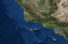
- This map shows the change that has occurred at Devereux Slough in Goleta CA since 1954. Current on the ground restoration by UCSB and CCBER is moving this system closer to its historical extent and ecological function. You can find out more about the restoration process at this url: https://www.ccber.ucsb.edu/ncos-news.To learn more about using the Atlas please visit our tutorial here: SB Atlas Tutorial.
Please contact Dustin Pearce (dustin.pearce@consbio.org) if you have any questions on this map.
- Location
- Credits
- Dustin Pearce
- Use Constraints
 This work is licensed under a Creative Commons Attribution 3.0 License.
This map is visible to everyone
Included in
1 Public Gallery
About the Map Author
SB Atlas Admin
Admin Account with Santa Barbara County Conservation Blueprint
The purpose of the Blueprint is to provide a public data platform and common language to support in depth conversations and decisions about our shared aspirations. This collaborative project aims to describe the current landscape, natural resources, and community values about land in Santa Barbara...